About me
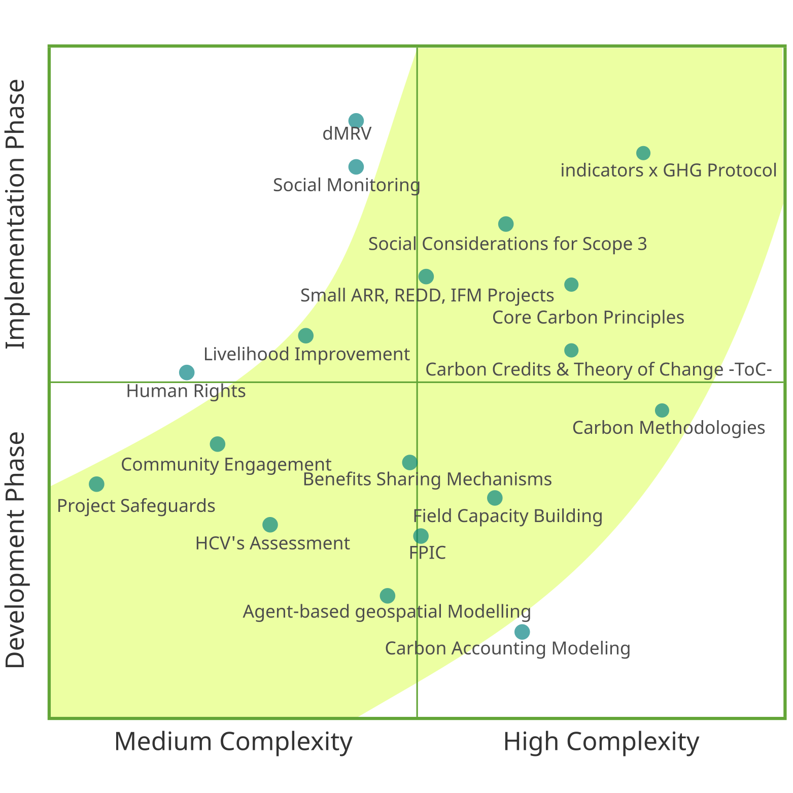
Interdisciplinary Forestry Engineer & Anthropologist (MSc Environmental Modeling) driving safeguard compliance and M&E for complex carbon projects (Agroforestry, ARR, REDD+, IFM, ANR activities). I integrate deep technical expertise in geospatial data tools and carbon methodologies with social science to optimize benefit-sharing, FPIC, and equitable mitigation strategies, and am dedicated to translating technical frameworks into actionable, community-driven results. Safeguard Leadership: Directs compliance across Gold Standard, VCS, and jurisdictional frameworks, ensuring rigorous adherence to environmental and social standards project activitivies M&E & Data Tools: Leverages advanced GIS and geospatial modeling to design robust Safeguard Systems (SIS) and track socio-economic indicators in implementation. Stakeholder Engagement: Train to facilita high-quality consultations, Free Prior and Informed Consent (FPIC), horizontal project structures, and on-the-ground capacity building. Fluent in English, Spanish, and Portuguese. (see: My technical carbon skills).
      graph LR
      B(Qualifications) --> F[Forestry Engineer and Anthropologist]
      B --> G[Master in Analysis and Modeling of Environmental Systems]
      graph LR
      D(Skills) --> K[Safeguard compliance & social impact assessment]
      D --> L[GIS modeling, remote sensing & data analysis]
      D --> M[Lead implementation, monitoring & evaluation]
      D --> N[Python, R & GIS automation tools]
      D --> O[Languages: Spanish, English, Portuguese]
      graph LR
      E(Experience) --> O[Seven+ years in the voluntary carbon market]
      E --> P[Current: Freelance Consultant for carbon project developers]
      E --> Q[Previous: Carbon Compliance Expert at Earthshot Lab]
      E --> R[Previous: Regional Lead NBS at South Pole]
Carbon Development & Operations Download CV/resume
Social Safeguards & Community Specialist
2- Qualifications

Master of Science (M.Sc.) in Analysis and Modeling of Environmental Systems
- Federal University of Minas Gerais, Institute of Geosciences (IGC / UFMG)
- Belo Horizonte, Brazil
- Mar 2015 - May 2017
Topics: Improved Forest Management Finance Analysis Forest Management Deforestation Degradation
graph LR

    subgraph Technical
    A[Analysis & Modeling]:::skillbox
    B[Statistical Methods]:::skillbox
    C[Computational Techniques]:::skillbox
    end

    subgraph Practical
    D[Fieldwork Experience]:::practical
    E[Environmental Data Collection]:::practical
    F[Data Management]:::practical
    end

    subgraph Communication
    G[Research ]:::communication
    H[Academic Writing]:::communication
    I[Audience Engagement]:::communication
    end


    A --> B & C
    D --> E --> F
    G --> H & I

    B -.-> E
    C -.-> F
    F -.-> G

Bachelor of Science (B.Sc.) in Anthropology
- University of Antioquia, Faculty of Social Sciences and Humanities
- Medellín, Colombia
- Dec 2005 - Dec 2013
Topics: Human Rights-based Approach FPIC Land Use Tenure Deforestation
graph LR
    subgraph Research_Methods
        D[Ethnography]:::methods
        E[Qualitative Analysis]:::methods
        F[Participatory Methods]:::methods
    end

    subgraph Focus_Areas
        G[Human Rights]:::focus
        H[Indigenous Communities]:::focus
        I[Social Change]:::focus
    end

    subgraph Applied_Skills
        J[Land Use Mapping]:::applied
        K[FPIC Implementation]:::applied
        L[Theory of Change]:::applied
    end

    %% Main connections
    D --> J & K
    E --> J & L
    F --> K

    %% Focus area connections
    G --> K
    H --> J & K
    I --> L & F

    %% Cross-area relationships
    J -.-> H
    K -.-> G & H
    L -.-> I & F

Bachelor of Engineering (B.Eng.) in Forestry
- National University of Colombia, Faculty of Agrarian Sciences
- Medellín, Colombia
- Jan 2005 - Jun 2012
Topics: Forest Inventory LiDAR & Remote Sensing Sustainable Forest Management Forest Economics Forest Mapping
graph LR
    subgraph Core_Knowledge
        A[Sustainable Forest Management]:::core
        B[Forest Science]:::core
    end

    subgraph Technical_Skills
        C[Forest Inventory]:::tech
        D[LiDAR & Remote-Sensing]:::tech
        E[Economic Outcomes]:::tech
    end

    subgraph Practical_Applications
        F[Forest Mapping]:::practical
        G[Harvesting Plan]:::practical
        H[Resource Assessment]:::practical
    end

    subgraph Management_Approach
        J[Sustainability Analysis]:::management
        K[Environmental Impact Assessment]:::management
    end

    %% Main Connections
    A & B --> C
    C --> F & H
    D & E --> F

    %% Integration Lines
    F --> G
    H --> K & J
    B --> K

    %% Cross-domain Relationships
    C -.-> H
    F -.-> H
    K -.-> G

    %% Technology Integration
    D -.-> H
    E -.-> F
3- Interests
My work focuses on the intersection of social equity, environmental safeguards, and community empowerment within nature-based solutions and climate projects. I leverage analytical tools, particularly GIS and participatory methods, to ensure projects are designed and implemented effectively and ethically.
| Area | Focus |
|---|---|
| Social Safeguards & Compliance: | Leading safeguard conformance across VCS, CCB, Gold Standard, Social Carbon, and VCI. Designing safeguard information systems, benefit-sharing mechanisms, grievance redress, and gender-responsive planning for REDD+, ARR, and jurisdictional programmes. |
| Community & Stakeholder Engagement: | Leading community-driven consultation processes, FPIC implementation, capacity building, and inter-ethnic dialogue platforms. Designing horizontal structures for risk mitigation and high-quality participatory engagement. |
| Implementation, Monitoring & Evaluation: | Leading project implementation and M&E workstreams, including indicator selection, monitoring strategy design, verification support, and compliance reviews with international climate mitigation rules. |
| Geospatial & Analytical: | Utilizing GIS tools, remote sensing, and workflow design for safeguard indicator assessment, risk analysis, social impact assessment, and land-use planning across Indigenous and local community territories. |
| Data Tools & Automation: | Developing and maintaining tools and systems to analyse sustainability data. Designing automated tools for safeguard and SDG reporting using Python, R, and GIS. Structuring information clearly and translating complex analysis into actionable insights. |
| Human Rights Approach: | Integrating human rights principles into all project phases, ensuring equitable benefit sharing, respecting community rights through FPIC, and designing culturally appropriate grievance mechanisms across Africa, Latin America, and Southeast Asia. |
4- Short-experience
| Position | Company | Period | Time (Years) | Type |
|---|---|---|---|---|
| Freelance Consultant, Carbon Standards & NCS Advisory | Multiple Clients | Oct 2024 – Present | 1.5+ | Private sector |
| Carbon Compliance Expert, Carbon Development | Earthshot Lab | Oct 2023 - Sep 2024 | 1 | Private sector |
| Regional Lead NBS, Climate Projects | Jan 2023 – Nov 2023 | 0.9 | Private sector | |
| South Pole | ||||
| Senior Project Coordinator, Forestry & Land Use Projects | Jun 2020 – Dec 2022 | 2.5 | Private sector | |
| South Pole | ||||
| GIS, Forestry & Land Use Projects | Jun 2017 – Dec 2020 | 3 | Private sector | |
| South Pole | ||||
| Specialist: Social and Forestry consultancy | May 2016 - Jul 2016 | 0.17 | Public sector | |
| Universidad Nacional de Colombia | ||||
| Environmental Analyst | May 2016 - Dec 2016 | 0.67 | Non-Profit Organization | |
| WWF | ||||
| Forestry and Anthropologist (Consultancy) | Sep 2013 - May 2014 | 0.67 | Private sector | |
| Renovatio Group Ltda | ||||
| Assistant professor | Jul 2015 - Dec 2015 | 0.5 | ||
| Universidade Federal de Minas Gerais | Public sector | |||
| Land Tenure and Land Use Advisor | Jul 2013 - Feb 2015 | 1.67 | Non-Profit Organization | |
| Indigenous Organization of Antioquia |
Experience by region
5- References
Academic references
I highlight the role in my bachelor carrer of a Antropologist Rober Dover who pass away. Robert teaches me solve-thinking skills to work with traditional communities. Who was he?, I highlight the fact to had the possibility of having a classroom with ones of those teachers that think outside the black box and always are in the knowledge frontier:
- Britaldo Soares-Filho
- Sonia Maria Carvalho
- Dolors Almenteras
Profesional references:
Throughout my journey, I’ve had the privilege of working with amazing colleagues who have guided me in improving my work skills, time management, communication, and the ability to raise important concerns. Here are a few of the remarkable individuals I’ve had the pleasure of working:

Abel Marcarini: Abel is a carbon project lead for Brazil at Earthshot Labs. He has more than 10 years working on Nature Based Solutions for the voluntary carbon market and academic background in forestry. Before Earthshot Lab, Abel worked for Verra for two years and for South Pole for seven years.
Beatriz Zapata: Beatriz Zapata is a forest engineer with vast experience in carbon forest project initiatives. She has deep technical knowledge of methodologies, tools, and guidelines of the main standards used in the AFOLU sector, such as VCS, CCBS and Gold Standard. Beatriz work for South Pole since seven years ago.

Milena Agudelo: Milena is a manager for Nature Climate Solutions at Verra, responsible for reviewing registration and verification requests ensuring quality and integrity of ALM and WRC projects. She helps develop updates to existing rules and procedures and provides technical input for the development of new methodologies. Milena holds a bachelor’s degree in Forest Engineering and a MSc in Forestry and Environmental Conservation. Previously, she supported Climate Friendly and South Pole for six years.

David Montoya González David hold eight years of extensive experience in Remote Sensing and GIS. He leads the Remote Sensing and GIS team in TerraGlobal, using innovative software and tools that meet carbon market and impact standards and support community-based geospatial community monitoring. David worked for The National Department of Statistics (DANE) and South Pole for two years.
6- Tools
| Category | Tool/Platform | Description |
|---|---|---|
| Tools | ||
| Project | - A cloud-based project management tool. | |
| Collaboration | - A collaborative whiteboard platform that helps teams brainstorm, plan, and execute projects. | |
| Project | - A project management platform to collaborate on tasks, and track progress. | |
| Platforms | ||
| GIS Software | - A commercial GIS software package. | |
| Remote Sensing | - A commercial remote sensing software package. | |
| Remote Sensing | - A commercial remote sensing software package. | |
| Remote Sensing | - A commercial remote sensing software package. | |
| Databases | ||
| File Format | - A file format for storing geospatial data. | |
| File Format | - A client library for storing spatial data in Python. | |
| Open-source Software | ||
| GIS Software | - A free and open-source GIS software package. | |
| Remote Sensing | - A cloud-based platform for analyzing and visualizing geospatial data using Google’s infrastructure. | |
| Programming Languages | ||
| Basic | - A popular general-purpose programming language for geospatial data analysis. | |
| Basic | - A statistical programming language widely used for data analysis and visualization. | |
| Basic | - A versatile programming language commonly used for web development and interactive map applications. |
Author/Newsletter
I am a quantitative Forestry and Anthropology wizard who loves getting his hands dirty with GIS problems and Spatial Modelling.
My superpowers are technical carbon issues, in A/R, REDD+, Agroforestry, and Agriculture Land Management.
Schedule a meeting here: Calendar view.
Coffee farmer | Coffee seller
Our experimental brand

Since 2021 the love for Colombian coffee led us to start a coffee project in a small town in Colombia Concepción, Antioquia.
 Evocar coffee is a high-mountain coffee, regenerative agriculture of beans growning inside of cloud-forest and processed using traditional methods.